CELESTAVIA · From the airport to the parks, from downtown to the coast
The aerial network for Central Florida
Central Florida receives more visitors than any other destination in the United States, and nearly every one of them, like nearly every resident, moves by car. This is the missing layer: electric, driverless, above the traffic and running around the clock.
Transport system: US$ 8,938 million 348-mile network First sections in 24 monthsExecutive summary
Central Florida does not lack roads, or ambition. Interstate 4 was rebuilt through the heart of Orlando, the airport is the busiest in the state, Brightline already connects it with Miami, and SunRail runs 61 miles from DeLand to Poinciana. What the region still lacks is a way for its 76.7 million annual visitors and its 2.9 million residents to move between the airport, the theme parks, the convention district, downtown and the coast without a car.
The Celestavia proposal for Central Florida is a suspended aerial network of 348 miles of double track, electric, driverless and continuously running, strung on towers at intervals of about 330 feet, in 18 corridors. Its first phase is the tourist core: 65 miles linking Orlando International Airport, the Convention Center and International Drive, Universal and Epic Universe, the Walt Disney World resort area and downtown Orlando. The second phase reaches the suburbs; the third, Daytona Beach, the Space Coast and Lakeland.
Methodological note. The figures are profile-level pre-studies, built on the Celestavia system's unit reference (about US$ 19.54 million per mile, US$ 12.144 million per kilometre) adjusted by a terrain factor specific to each corridor —the same parameters as every other Celestavia programme, so that the figures are comparable. That reference was calibrated on the Latin American and European programmes, not on United States construction prices, which are generally higher; the amounts on this page should be read as an order of magnitude to be confirmed in Phase 0, not as a quotation.
Terrain factors used
| Factor | Applies to |
|---|---|
| 1.00 | Open country along I-4 to DeLand, Daytona Beach and Lakeland, and the Four Corners link. |
| 1.10 | Suburban corridors: Winter Park and Sanford, UCF and Oviedo, Lake Nona and Kissimmee, West Orange, Apopka, St. Cloud, Poinciana and Clermont. |
| 1.15 | The Walt Disney World resort loop, the Beachline to Cocoa and Port Canaveral, and the Kennedy Space Center branch across the lagoon. |
| 1.25 | The tourist and urban core: the airport, International Drive, Universal, the theme-park corridor and downtown Orlando. |
The four factors in this table are exactly those used in the route table; none is used outside it. Visitors: Visit Orlando, 2025. Residents: Orlando–Kissimmee–Sanford metropolitan area, 2,940,513 (U.S. Census Bureau, American Community Survey 2024 1-year).
Diagnosis: what the region is missing
It is worth starting with what Central Florida has already built, because any proposal that ignores it is not worth reading: a rebuilt I-4, a commuter rail line, an intercity rail link to South Florida, a bus network and one of the largest airports in the country. None of that is the subject of this proposal. What remains open is of a different kind.
| Gap | Documented situation | Celestavia response |
|---|---|---|
| A car for every trip | The theme parks, International Drive and the Convention Center have no rail connection to the airport or to each other. SunRail does not reach the airport or the parks; its extension east and west, the Sunshine Corridor, is in a Project Development and Environment study due to run until May 2027, with a cost reported at about US$ 4.4 billion. | A 65-mile Phase I that links the airport, the convention district, Universal and Epic Universe, the Walt Disney World area and downtown, with service every few minutes. |
| The price of a lane | I-4 Ultimate rebuilt 21 miles of interstate through Orlando for about US$ 2.3 billion —roughly US$ 110 million per mile—, more than seven years of construction. | An aerial track at about US$ 26 million per mile including megastations, built in 5-mile sections that enter service one at a time. |
| Road safety | Florida recorded about 3,100 traffic deaths in 2024 according to the state's crash data, among the highest totals in the country. | Segregated guided track, no level crossings, no human driver in the cabin and AI-based control. The target is zero accidents. |
| Visitors who do not know the roads | Most of the 76.7 million visitors arrive by air or car and drive rental cars on roads they do not know, between hotels, parks and the airport. | A direct, signposted service from the airport terminal to the hotel and park districts, with luggage carried in the same cabin. |
| Hurricanes | Hurricane Milton crossed Central Florida in October 2024, knocking down traffic signals and power lines in Orlando and leaving more than three million Floridians without power. | Towers designed for hurricane wind loads, cabins sheltered in stations during a storm, and a system that becomes an emergency route once the wind drops, without waiting for roads to be cleared. |
Sources: SunRail (Sunshine Corridor PD&E study, 2025) and regional press on its cost estimate; FDOT and regional press on I-4 Ultimate (21 miles, US$ 2.3 billion at financial close; the per-mile figure is Celestavia's division); Florida Department of Highway Safety and Motor Vehicles crash data as reported for 2024 (preliminary and revised totals of 3,164 and 3,098); Visit Orlando; regional press on Hurricane Milton. Figures are quoted rounded and for context; readers who need precision should go to the source.
Main objective and specific objectives
Main objective. To give Central Florida a layer of guided, aerial, electric transport that handles the trips between the airport, the visitor districts, downtown and the coast, and that takes those trips off the interstate without widening it again.
Airport to hotel without a car
From the MCO terminal to International Drive, Universal, Lake Buena Vista and downtown, with luggage, on a single ticket.
Park to park
The theme parks, the Convention Center and the hotel districts linked to each other, not only to the airport.
Workers first
The people who keep the parks and hotels running live in Kissimmee, Poinciana, Apopka, Pine Hills and Sanford. Phase II is built for them.
Coast to coast of the region
Daytona Beach, Port Canaveral and the Kennedy Space Center to the east, Lakeland to the west, linked to the airport and the parks.
Zero deaths on the road
Replace road trips with trips on a segregated guided track, in a state with one of the highest numbers of traffic deaths in the country.
Zero operating emissions
100 % electric traction, with solar generation on the tower easement itself, in the Sunshine State.
Tourism, airport and conventions: the platform that already exists
Central Florida is the most visited destination in the United States. In 2025 it received a record 76.7 million visitors; Orlando International Airport handled 57.7 million passengers, the busiest in Florida and seventh in the country; the Orange County Convention Center is the second-largest convention center in the United States; and Universal's Epic Universe, which opened in May 2025, added a fourth park to the Universal resort.
The platform exists; what it lacks is a way to move between its parts that does not depend on a car. Phase I follows exactly that geography: the Airport – Convention Corridor (Route 1) from MCO along the Beachline to the Convention Center, Epic Universe and Universal; the Theme Parks Corridor (Route 2) from the Convention Center past SeaWorld to Disney Springs, EPCOT and Magic Kingdom; the Walt Disney World Loop (Route 3); and the two downtown links, the I-4 Downtown Trunk (Route 4) and the Downtown – Airport Express (Route 5).
Private land, stated plainly. Several Phase I stations —Universal, Epic Universe, SeaWorld, Disney Springs and the Walt Disney World parks— are on or next to private property, and the Walt Disney World Loop (Route 3, 12 miles, US$ 279 M) runs inside the resort. The Southern Arc (Route 8) and the Four Corners link (Route 17) also end at Animal Kingdom, inside the same resort; the Kennedy Space Center branch (Route 14) ends on NASA land, and the Port Canaveral station is on port-authority land. They are drawn here because that is where the trips are, not because any owner has agreed to them. Every one of those stations is subject to agreement with the land owner; where there is no agreement, Routes 8 and 17 stop at the public right-of-way outside the resort, Route 3 is removed from the programme, and the Space Coast stations move to the nearest public land.
Sources: Visit Orlando (2025 visitor count, announced in 2026); Airports Council International – North America, 2025 passenger rankings (57,675,573 passengers at MCO); Orange County Convention Center (2,053,820 ft² of exhibition space); Universal Orlando (Epic Universe opening, May 2025); U.S. Census Bureau (ACS 2024). The alignment of the Phase I corridors is a Celestavia proposal that has not been presented to any authority or landowner.
The Celestavia Central Florida network: routes and alignment
The alignment does not replicate the road network: it complements it. It rests on four principles: (i) start where the trips are —the airport, the visitor districts and downtown—; (ii) serve the workforce, which lives in the suburbs to the south, west and north; (iii) reach the region's other gateways —Sanford airport, Port Canaveral, the Kennedy Space Center, Daytona Beach and Lakeland—; and (iv) end every corridor at an interchange with SunRail, Brightline, LYNX or an airport.
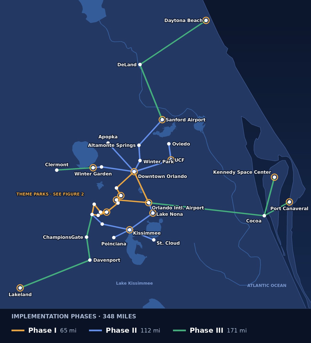
Figure 1. Reference schematic of the Celestavia Central Florida network by implementation phase, drawn on the real coordinates of the nodes. Gold rings mark the 14 megastations. It is not a final alignment or an official cartographic document: the final alignment is set in the Phase 0 studies.
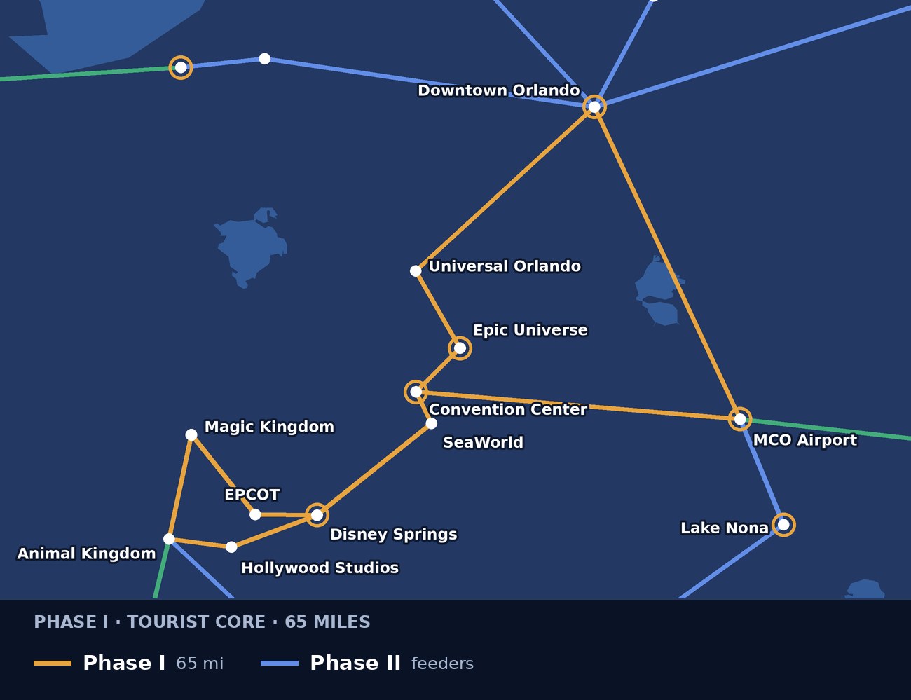
Figure 2. The Phase I tourist core: the airport, the Convention Center and International Drive, Universal and Epic Universe, the Walt Disney World area and downtown Orlando. Stations on private land are subject to agreement with the land owner.
Route table
| No. | Name | Alignment | Setting | Miles | Phase |
|---|---|---|---|---|---|
| 1 | Airport – Convention Corridor | Orlando International Airport (MCO) – Orange County Convention Center – Epic Universe – Universal Orlando | Urban / tourist | 18.6 | I |
| 2 | Theme Parks Corridor | Orange County Convention Center – SeaWorld – Disney Springs – EPCOT – Magic Kingdom (Transportation and Ticket Center) | Urban / tourist | 12.4 | I |
| 3 | Walt Disney World Loop | Disney Springs – Hollywood Studios – Animal Kingdom – Magic Kingdom (Transportation and Ticket Center) | Resort grounds | 12.4 | I |
| 4 | I-4 Downtown Trunk | Downtown Orlando (LYNX Central Station) – Universal Orlando | Urban core | 9.3 | I |
| 5 | Downtown – Airport Express | Downtown Orlando (LYNX Central Station) – Orlando International Airport (MCO) | Urban | 12.4 | I |
| 6 | North Line | Downtown Orlando (LYNX Central Station) – Winter Park – Altamonte Springs – Orlando Sanford International Airport | Suburban | 21.7 | II |
| 7 | University Line | Downtown Orlando (LYNX Central Station) – University of Central Florida – Oviedo | Suburban | 18.6 | II |
| 8 | Southern Arc | Orlando International Airport (MCO) – Lake Nona – Kissimmee – Celebration – Animal Kingdom | Suburban | 31.1 | II |
| 9 | West Orange Line | Downtown Orlando (LYNX Central Station) – Ocoee – Winter Garden | Suburban | 12.4 | II |
| 10 | Apopka Line | Downtown Orlando (LYNX Central Station) – Apopka | Suburban | 12.4 | II |
| 11 | Osceola Line | Kissimmee – St. Cloud | Suburban | 9.3 | II |
| 12 | Poinciana Line | Kissimmee – Poinciana | Suburban / wetland edge | 6.2 | II |
| 13 | Space Coast Corridor | Orlando International Airport (MCO) – Cocoa – Port Canaveral | Open plain and lagoon | 49.7 | III |
| 14 | Kennedy Space Center Branch | Cocoa – Kennedy Space Center Visitor Complex | Lagoon and refuge edge | 15.5 | III |
| 15 | I-4 Northeast Corridor | Orlando Sanford International Airport – DeLand – Daytona Beach | Open plain | 49.7 | III |
| 16 | I-4 Southwest Corridor | ChampionsGate – Davenport – Lakeland | Open plain | 34.2 | III |
| 17 | Four Corners Link | Animal Kingdom – ChampionsGate | Open plain | 9.3 | III |
| 18 | Lake County Line | Winter Garden – Clermont | Suburban | 12.4 | III |
| TOTAL | 348 | ||||
Each length is the mean of the straight-line distance and the road distance computed over OpenStreetMap between the nodes shown, rounded to 5 km and shown in miles to one decimal; the total is computed before rounding, so the rows add up to a few tenths less. None comes from a topographic survey. The final alignment is set in the Phase 0 studies.
Implementation phases
I Phase I — the tourist core
65 miles. The airport, the Convention Center and International Drive, Universal and Epic Universe, the theme-park corridor, the Walt Disney World loop and the two links to downtown Orlando. This is where the trips are and where the system starts to earn revenue. Infrastructure investment: US$ 1,570 M.
II Phase II — the workforce
112 miles. North to Winter Park, Altamonte Springs and Sanford airport; east to UCF and Oviedo; the southern arc from the airport through Lake Nona and Kissimmee to the parks; west to Winter Garden and Apopka; and south to St. Cloud and Poinciana. Infrastructure investment: US$ 2,405 M.
III Phase III — the region
171 miles. The Beachline to Cocoa and Port Canaveral with a branch to the Kennedy Space Center, I-4 northeast to DeLand and Daytona Beach, I-4 southwest to Lakeland, the Four Corners link and Clermont. Infrastructure investment: US$ 3,555 M.
One system, every mode
Celestavia is a general-purpose guided transport system: the track, the towers and the cable are the same for everything that runs on them, and what changes from one service to another is the carriage that is coupled on.
| Service | Transport unit | Intended use in Central Florida |
|---|---|---|
| Passengers | Air-conditioned 9- and 18-seat cabins and carriages, with room for luggage | Airport to hotel, park to park, and the daily commute of the people who work in them. |
| Parcels and hotel supply | Light carriage, with an automated warehouse at the station | Linen, food and goods for the hotel and park districts, and e-commerce distribution, off the road at night. |
| Containerised cargo | 20-foot, 25 t chassis; two coupled (50 t) for longer boxes | Port Canaveral and the warehouse districts along the Beachline and I-4. |
| Emergency | Priority dispatch for ambulance, fire and rescue | The whole network, with priority over all other traffic, and evacuation support before a hurricane. |
Station types and sizing
| Type | Typical spacing | Function | Estimated number |
|---|---|---|---|
| Multifunctional megastation | at the region's gateways and districts | Interchange, power generation, fibre and 5G hub, automated warehouse, control centre, retail and public-service units. Located at Orlando International Airport, Downtown Orlando, Convention Center / International Drive, Epic Universe / Universal, Disney Springs, Lake Nona, Kissimmee, Orlando Sanford International Airport, UCF, Winter Garden, Port Canaveral, Kennedy Space Center, Daytona Beach and Lakeland. | 14 |
| Intermediate station | every 1.5 to 3 miles outside the core | Passenger boarding and alighting, light cargo, covered platforms. | about 127 |
| Stop | every quarter to half mile in the core | Pedestrian access to hotels, parks and offices, integrated with LYNX, SunRail and Brightline where they meet. | about 142 |
There are more megastations than the programme average of one per 31 miles (348 miles would give 11), because the region's airports, ports and visitor districts each need one. Stops are derived from the 53 miles of core corridors at about one every 0.37 miles; intermediate stations from the remaining 295 miles at one every 2.3 miles. Everything is adjusted in detailed design.
Estimated investment (profile-level pre-studies)
The figure this page leads with is the transport system: infrastructure plus megastations, US$ 8,938 million. That is what it costs to build the network.
Cost per mile
| Concept | Total | Per mile | Per km |
|---|---|---|---|
| Infrastructure, without megastations | US$ 7,529 M | US$ 21.64 M | US$ 13.45 M |
| 14 megastations × US$ 100.63 M | US$ 1,409 M | US$ 4.05 M | US$ 2.52 M |
| Transport system, with megastations | US$ 8,938 M | US$ 25.69 M | US$ 15.96 M |
| For reference: I-4 Ultimate, 21 miles of interstate | about US$ 2,300 M | about US$ 110 M | about US$ 68 M |
Celestavia infrastructure
348 miles of two-way track, with its intermediate stations and stops, excluding land and megastations. That is US$ 21,637,860 per mile, the weighted average (factor 1.1071) of the terrain factors of the 18 corridors.
14 multifunctional megastations
Power generation and transmission, fibre optics and 5G, passengers and cargo, AI video surveillance, mobile booking, automated warehouses and a maintenance fleet, with rentable units for medical practices, retail, public-service offices and meeting space.
The community component, and why it is shown separately
The other Celestavia programmes include a third line, sized at US$ 2,265 per inhabitant, which funds education, integral health, housing and a subsidised fare. Applied to the 2,940,513 residents of the metropolitan area it would come to US$ 6,660 million.
That figure should not be read as a Central Florida investment requirement. The parameter was calibrated for settings where public health, education and housing coverage does not exist, and it is kept here only for methodological comparability with the other programmes. Added to the system, the nominal grand total would be US$ 15,598 million; the useful figure for Central Florida is the transport system, and it is the one used throughout the rest of this page.
Infrastructure is obtained by applying the unit reference of US$ 12.144 million per kilometre (about US$ 19.54 million per mile) to each corridor with its terrain factor. The 14 megastations are valued at US$ 100.63 million each, the same parameter as every other Celestavia programme. The I-4 Ultimate figure is the amount reported at financial close; dividing it by length is Celestavia's arithmetic, and a rebuilt interstate is not the same product as a new transit line. All figures are Celestavia calculations, not quotations.
Who builds what: scope split
Of the investment in the transport system —US$ 8,938 million— most is not carried out by Celestavia but by the companies of the Celestavia Intermodal Consortium.
US$ 7,597 M
US$ 1,341 M
Celestavia keeps only the on-board electronics, the software and the system control, plus integration engineering and certification. Everything else —towers, foundations, cables, cabins, stations, power grid, fibre and 5G— is tendered to third parties. The breakdown of the infrastructure line (US$ 7,529 million) is as follows:
| Component | Executed by | % of line | Amount |
|---|---|---|---|
| Towers — structural fabrication | Third parties | 18 % | US$ 1,355 M |
| Tower foundations and civil works | Third parties | 9 % | US$ 678 M |
| Cables, fittings and stringing | Third parties | 9 % | US$ 678 M |
| Tower and cable erection and installation | Third parties | 8 % | US$ 602 M |
| Cabins, carriages and chassis — fabrication | Third parties | 16 % | US$ 1,205 M |
| Intermediate stations and stops — works | Third parties | 7 % | US$ 527 M |
| Generation, substations and power grid | Third parties | 13 % | US$ 979 M |
| Fibre optics and 5G — equipment and laying | Third parties | 4 % | US$ 301 M |
| On-board electronics, control and sensing | Celestavia | 8 % | US$ 602 M |
| Software, AI, control centres, booking and fare collection | Celestavia | 4 % | US$ 301 M |
| Systems engineering, integration and certification | Celestavia | 4 % | US$ 301 M |
The composition percentages are structural and apply equally to every Celestavia programme. Civil works, foundations, erection and station construction can be contracted to Florida firms; quantifying the share of fabrication that can be done in the state is Phase 0 work.
Relationship with SunRail, Brightline and LYNX
Central Florida already has three public transport layers, and a fourth is being studied. SunRail runs 61 miles and 17 stations from DeLand to Poinciana since its DeLand station opened in August 2024; Brightline has connected Orlando International Airport with South Florida since September 2023; LYNX runs the region's bus network; and the Sunshine Corridor study is examining a SunRail extension to the airport, the Convention Center and the theme-park area. This proposal overlaps all of them in places, and it is better to say so plainly.
It is not competition
SunRail and Brightline carry long, fast trips on fixed corridors. Celestavia covers the short and medium trips between the places those corridors do not stop at: hotels, parks, the Convention Center and neighbourhoods.
It is a feeder
Every Celestavia corridor ends at or passes an interchange: SunRail at Sanford, Winter Park, downtown, Kissimmee, Poinciana and DeLand; Brightline at the airport; LYNX at its central station. Phase 0 design starts from the Sunshine Corridor study, not against it.
It can come first
Built in 5-mile sections that each enter service on their own, the Phase I tourist core can operate while larger rail projects complete their studies, funding and construction.
Data from SunRail (DeLand opening, August 2024; Sunshine Corridor PD&E study) and Brightline (Orlando service from September 2023). The comparison with this page's routes is Celestavia's reading.
Engineering adapted to Central Florida
Hurricane winds
Towers designed for the Florida Building Code wind loads of each county, a protocol to suspend service and shelter cabins in stations, and resumption of service without surface repairs once the storm has passed.
Lightning
Central Florida has some of the most frequent lightning in the United States. Every tower is grounded and carries surge protection, and the cable, the cabins and the power system are designed to keep running through summer storms.
Karst and sinkholes
The region sits on limestone, and sinkholes are a known hazard. Each tower location is investigated geotechnically, and a tower can be moved without redesigning the line —something a road cannot do.
Airspace
The network passes close to Orlando International, Orlando Sanford, Orlando Executive and Kissimmee Gateway airports. Tower heights and alignments near them are set with the Federal Aviation Administration under its obstruction rules (14 CFR Part 77).
Wetlands and the lagoon
The Beachline and the Kennedy Space Center branch cross wetlands, the St. Johns basin and the Indian River Lagoon. An aerial line touches the ground once every 330 feet, which is why it is proposed there instead of new pavement; environmental permitting is still required.
Heat and humidity
Air-conditioned cabins, shaded and ventilated stations, and electrical equipment rated for heat and humidity all year round.
Benefits of the system
For the visitor
From the airport to the hotel and from park to park without renting a car, without parking and without learning the interstate.
For the worker
A reliable commute from Kissimmee, Poinciana, Apopka or Sanford to the parks and hotels, around the clock, matched to shift work.
Safety
A segregated track with no level crossings and no driver: every trip moved onto the network is a trip removed from the crash statistics.
Emissions
100 % electric traction, with solar generation on the easement itself.
Connectivity
A 5G cell and a fibre hub on every tower: the transport network is also the corridor's telecommunications network.
Resilience
Service does not depend on the road surface; after a hurricane the system becomes an emergency route as soon as it is safe to run.
Comparison with adding interstate lanes
| Criterion | Interstate widening | Celestavia |
|---|---|---|
| Cost per mile | About US$ 110 M on I-4 Ultimate | About US$ 26 M including megastations |
| Land | A continuous strip, with acquisition along the whole alignment | A few square yards per tower, every 330 feet |
| Construction | Years of lane closures on the busiest corridor | 5-mile modules, each in service on its own |
| Induced traffic | New lanes fill up again | Capacity that does not add cars |
| Accidents | Inherent to human drivers | Guided track, target of zero |
| Operating emissions | Those of the vehicle fleet | Zero |
Comparison with other transport modes
| Passenger feature | Celestavia | Train | Bus | Gondola (aerial cable car) | Car |
|---|---|---|---|---|---|
| Designed for zero accidents | Yes | No | No | No | No |
| No environmental pollution | Yes | No | No | Yes | No |
| Biosecurity system | Yes | No | No | No | No |
| High security with real-time AI | Yes | No | No | No | No |
| Predictable arrival time | Yes | No | No | Yes | No |
| Direct trip, no intermediate stops | Yes | No | No | No | Yes |
| Ecological footprint at most 1/500 of a road | Yes | No | No | Yes | No |
| Zero road traffic: runs on an overhead cable | Yes | No | No | Yes | No |
| Driverless 24/7 service | Yes | No | No | No | No |
| Suite-style, personalised transport | Yes | No | No | No | No |
| Mountain to mountain without a tunnel | Yes | No | No | Yes | No |
| Grades up to 40 % (simulated) | Yes | No | No | Yes | No |
| Crossing without a bridge | Yes | No | No | Yes | No |
| Flood risk | No | Yes | Yes | No | Yes |
| Door-to-door parcel delivery | Yes | No | No | No | Yes |
| Booking via mobile app | Yes | No | No | No | No |
| Automatic cabin disinfection | Yes | No | No | No | No |
| Economical to build and run | Yes | No | Yes | Yes | No |
Hyperloop is not listed: no hyperloop system has operated commercially, and Hyperloop One closed in 2023.
Job creation
Applying the ratio used in the other Celestavia programmes, the full programme would mobilise in the order of 98,000 to 122,000 direct and indirect jobs over the whole construction period, plus the permanent operation of the system.
This figure should be read with care, and probably revised down. It is the aggregate of a deployment over several years, not simultaneous employment, and the ratio behind it —11 to 13.6 jobs per million dollars— comes from the Peru and Argentina programmes, where labour is a larger share of construction cost than in the United States. A Florida-specific estimate is Phase 0 work.
Celestavia estimate on the transport system (US$ 8,938 million), without the community component. It does not come from a Florida employment study.
Financial structure and participation
This page contains two different splits that should not be confused: who owns the programme and who carries out the works. They are percentages of different things and are not added together.
1. Ownership of the programme — 100 % of the company
75 % Celestavia
Contributes the technology, the on-board electronics, the control software, the systems engineering and the financial structuring of the programme.
25 % public partner
The State, the counties or a regional authority contribute the aerial easement and the concession framework, and share in the results in that proportion.
2. Execution of the works — 100 % of the transport system, US$ 8,938 million
85 % to third parties — US$ 7,597 M
Tendered among the companies of the Celestavia Intermodal Consortium, with preference for Florida contractors and suppliers.
15 % Celestavia — US$ 1,341 M
Only on-board electronics, software and control, plus integration engineering and certification. The full breakdown is under Scope split.
No figure on this page constitutes an offer. Section 334.30 of the Florida Statutes allows FDOT to enter into public-private partnerships to build, operate and finance transportation facilities, and is a natural route for a scheme of this kind; the final structure, and how an aerial guided system fits into the state's work program, local land-use rules and federal airspace rules, is agreed in Phase 0.
Florida Statutes, section 334.30 (public-private transportation facilities). The 75/25 ownership split is the structure used in the other Celestavia programmes and has not been discussed with any Florida authority.
Central Florida in the Celestavia network
This is the first Celestavia programme in the United States. It joins the published programmes in Ecuador, Colombia, Peru, Argentina, Panama, Mexico, Brazil, the Dominican Republic, Spain and Sierra Leone. Unlike the national programmes, it is a metropolitan and regional network, and its first phase is built around visitors rather than freight. It has no physical link to any of the others; its relationship with them is through the airport and Port Canaveral.
Implementation roadmap
| Phase | Content | Estimated timing |
|---|---|---|
| Phase 0 | Topographic, geotechnical (karst), hydrological and environmental studies; coordination with FDOT, CFX, MetroPlan Orlando, LYNX, SunRail and the airport authorities; FAA airspace review; agreements with private landowners in the visitor districts; legal framework for the concession; detailed design of the first section. | 18 to 24 months |
| Phase I | Airport – Convention Corridor, Theme Parks Corridor, Walt Disney World Loop (subject to agreement), I-4 Downtown Trunk and Downtown – Airport Express. Each 5-mile section enters service independently. | First sections at 24 months |
| Phase II | North Line to Sanford, University Line, Southern Arc, West Orange, Apopka, Osceola and Poinciana lines. | Years 3 to 5 |
| Phase III | Space Coast Corridor and Kennedy Space Center branch, I-4 northeast to Daytona Beach, I-4 southwest to Lakeland, Four Corners link and Lake County line. | Years 4 to 7 |
Execution is modular and industrialised: each 5-mile section is put into service on its own, so the programme does not depend on finishing a whole corridor before it starts serving passengers and earning revenue.
Conclusion
Central Florida has built an interstate, a commuter railway and an intercity rail link, and its visitors and workers still depend on the car for almost every trip between the airport, the parks, the hotels and their homes. The network proposed here —348 miles, a US$ 8,938 million transport system, 18 corridors and 14 megastations— is a technical answer to that dependency, not a promise. Every figure on this page states where it comes from. What is needed now is to test it against the agencies, the landowners and the people who know the region closely.
Contact
Do you represent a government, public body or landowner?
Request detailed technical and financial information to assess implementing Celestavia in your area.
Request informationThe figures in this summary are preliminary technical and financial pre-studies of the Celestavia project for Central Florida and are subject to the final feasibility studies.
A self-initiated document. Like the Panama, Spain, Mexico, Brazil and Dominican Republic profiles, this Central Florida profile was prepared by Celestavia on its own account, from public data and the system's unit cost reference. It does not derive from any plan submitted by or to any public authority or private landowner, and it has not been discussed with the Florida Department of Transportation (FDOT), the Central Florida Expressway Authority (CFX), MetroPlan Orlando, LYNX, SunRail, the Greater Orlando Aviation Authority, the Sanford Airport Authority, Canaveral Port Authority, NASA, the counties and cities the network crosses, the Central Florida Tourism Oversight District, or with Walt Disney World, Universal Orlando, SeaWorld or any other property owner. The alignment, the distances, the phasing and the amounts are profile-level estimates, subject to the Phase 0 feasibility studies.